Carmel
Bailey
Ballard-Barrett
Barrett
Belden
Carver
Cole
Crane
Fowler
Gilead
Gregory
Hill
Hughson
Kelley
Mt. Carmel Baptist
Old Baptist
Old Methodist
Old Presbyterian
Raymond Hill
Union Valley
Gregory Cemetery (a.k.a. Drewville Cemetery*)
Carmel, NY
| Current Status: | |
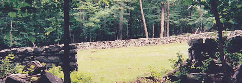
| Description: | The cemetery is approximately 110ft by 100ft and surrounded by a short stone wall. The entrance is on the north wall. All visible graves are located in the east portion of the cemetery. There is a small collection of stones in both the northeast and southeast corners. The northeast corner includes Esther Williams, d. Aug 17, 1822. Daniel Gregory of the 7th Dutchess NY Militia (d. 1817) and his wife, Elizabeth, and son, Lewis, are in the southeast corner. Between the two small groups of stones are approximately 60 fieldstone shards which are not identifiable. Some of these may have been moved here from cemeteries now submerged. The high-quality trapezoidal stone wall on three sides, compared with the typical farm wall on the east side, suggests that the pre-existing family cemetery may have been expanded by the 1906 reservoir construction project to accept additional unmarked graves. In all, there are about 57 markers, all but 8 being fieldstones. Gregory Cemetery might be largely occupied by reburials from the Drewville Cemetery, which might explain why Rev. Fisher mapped Gregory as "Drewville" while writing that Drewville had been elsewhere in the valley and inundated by the Croton Falls Reservoir. |
| GPS: | N41°22.124' W073°40.383'. Part of reservoir property. |
| Location: | East side of the abandoned Horse Pound Road path, north of Stebbins Road path, on a City-owned peninsula in the Croton Falls Reservoir. Accessible only from West Shore Drive at Stebbins Road. City DEP issues hiking permits, but not normally applicable to this land. |
| How To Access: | The peninsula is owned by New York City and, as reservoir land, its access is controlled by the NYC DEP. So, it requires permission from the DEP to make the trek to the cemetery. The journey begins at the bottom of Stebbins Road, at West Shore, where you can pick up the dirt portion of Stebbins Road. The trail is pretty obvious, although, the occasional downed tree necessitates a few detours. After about 15 minutes of eastward hiking, Stebbins ends at the north south Horsepound Road. At the intersection, there is a long stone wall which curves to the left (north) onto Horsepound. Follow the wall around and continue north on Horsepound Road. After a few minutes, turn right and walk up the gentle slope of the hill to find the cemetery. There is no obvious trail and it is not readily visible from Horsepound Road. The associated settlement, Gregory's Mills, located near Croton Falls Road and Horsepound Road, was displaced a century ago by the construction of the reservoir. |
| Tax Map No.: | Part of reservoir property |
| Owner of Record: | Land owned by City of New York, Department of Environmental Protection. |
| Size & Use: | |
| Earliest Gravestone: | Daniel Gregory, d. 13 Nov. 1817 |
| Most Prominent: | |
| Current Condition: | |
| Maintained By: | Town of Carmel |
| Repairs Needed: | |
| Troy #: | 1I |
*"Drewville Cemetery" is a misnomer. The original Drewville Cemetery was drowned by the Croton Falls Reservoir.
If it survives at all, this is the most probable location of an unmarked grave of Rev. Elnathan Gregory of the Gilead Meeting-House, a firebrand of the Revolution, on family land (despite another rumor of his being buried at Gilead). Rev. Gregory would be an earlier burial, if here (d. 1816), but it is not marked. "Pelletreau clearly and consisely says that Daniel Gregory was a son of Elnathan Gregory and was married to Elizabeth, a daughter of William H. Seeley. We have a Gregory book compiled by Grant Gregory in 1938 which says Daniel Gregory was a son of Josiah Gregory and was married to Elizabeth Gregory (a relative), and Elizabeth was a daughter of Rev. Elnathan." - Earle Grieg, Feb. 2010.
Mr. Michael Troy prepared this listing of interments, categorized the various stones he found, and prepared a map of the cemetery (layout can be viewed and printed by clicking here).
References: Pelletreau p.394; Fisher #43, Gregory.
Click on a name below for photo of headstone and location in cemetary. Generally only burials before 1912 are included in this website, however there may be later burials in this cemetery which are included here.
| GREGORY |
|
| WILLIAMS |
|
|